Bee Creek Road changes at its intersection with Newton Lane. South of that junction, a UTV can keep going. North of it, the road is for boots, bikes, and horses only. Most of the summer argument over Bledsoe State Forest comes down to that one intersection on the south end of the forest.
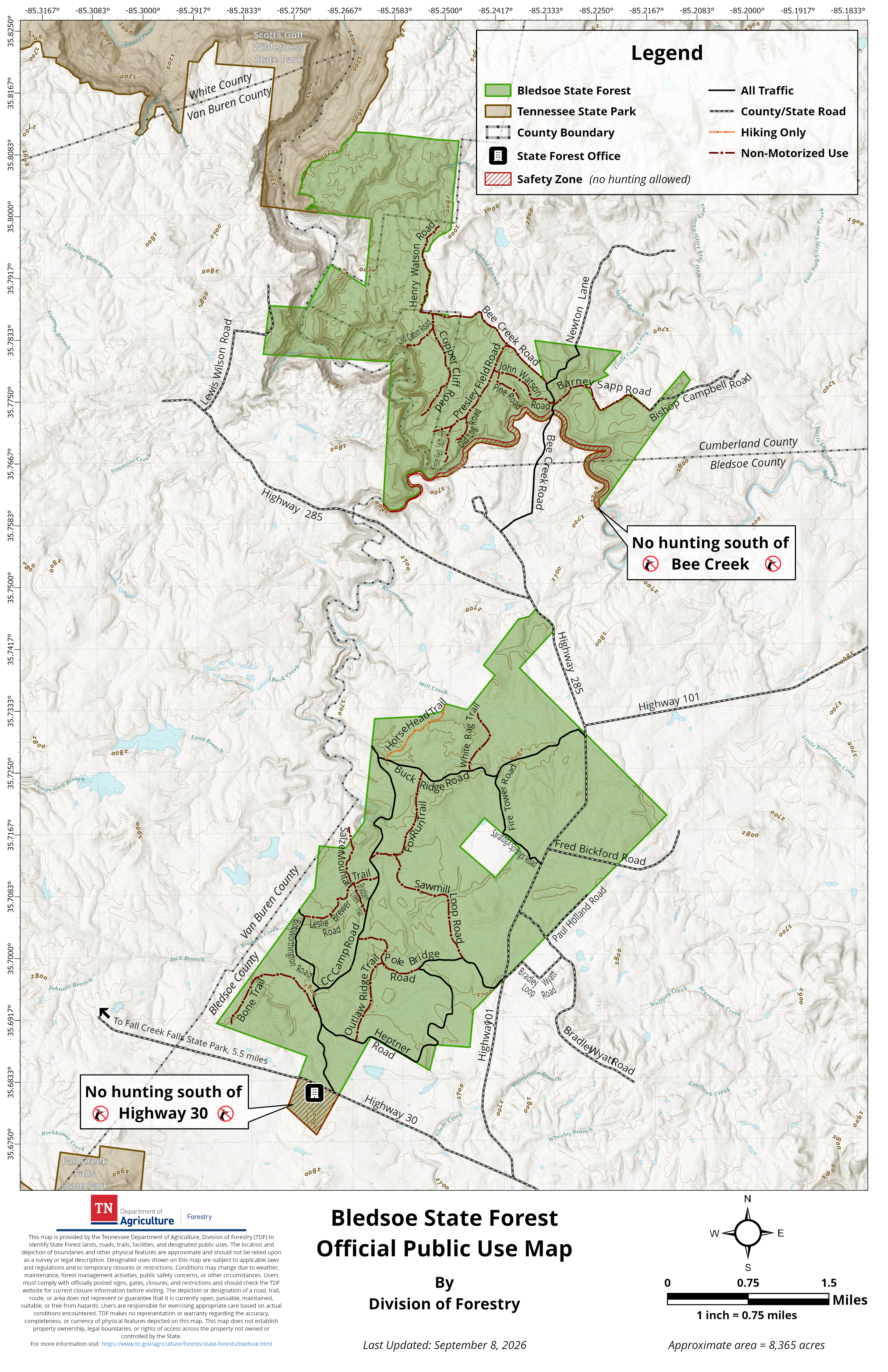
On September 4, 2026, the Tennessee Department of Agriculture's Division of Forestry published an updated public-use map for the forest. According to the department's release, the map was brought into line with road-use signs already standing at the south end of the forest. No part of the forest was closed to the public. The rules on the ground are mostly the same as they were in July. The paper now matches the signs, and anyone heading out this fall can know before leaving the house which roads take a motor.
The Line Runs Through One Intersection
Under the revised map, about 15.5 miles of forest roads stay open to motorized traffic. About 17 miles of other roads and trails are limited to hiking, biking, and horseback riding. These are the named roads and trails the release puts on each side:
| Open to motorized traffic | Nonmotorized only: hiking, biking, horseback |
|---|---|
| Bee Creek Road, south of Newton Lane | Bee Creek Road, north of Newton Lane |
| Newton Lane | Henry Watson Road |
| Buck Ridge Road | Old Cabin Road |
| Fire Tower Road | Copper Cliff Road |
| Saratoga Springs Road | Presley Field Road |
| Bob Worthington Road | Pine Road |
| CC Camp Road | John Watson Road |
| Heptner Road | Old Log Road |
| Pole Bridge Road | Barney Sapp Road |
| White Rag Trail | |
| Fox Run Trail | |
| Sawmill Loop Road | |
| Salzer Mountain Trail | |
| Bradden Creek Trail | |
| Leslie Brewer Road | |
| Bone Trail | |
| Outlaw Ridge Trail |
Two more rules aren't in the table. Every unnamed forest management road north of the Bee Creek Road and Henry Watson Road intersection is closed to motorized traffic. Horse Head Trail is foot traffic only, so horses and bikes aren't allowed on it either.
Riders keep nine named roads. The nonmotorized side has nearly twice as many named routes and slightly more mileage. Bee Creek Road is the only road that shows up in both columns, which is why the Newton Lane intersection is where people tend to get confused.
The release also says the Division of Forestry doesn't set OHV rules for county roads that run through or alongside the forest. The state map covers state forest roads. A county road that borders the forest isn't automatically under the same rules.
The official Bledsoe State Forest page links the updated public-use map. The map shows the forest boundary, road and trail designations, the forest office, and the safety zones where hunting isn't allowed. The page lists the main entrance at coordinates 35.681907, -85.269735 and says the forest is reached from Highways 285, 101, and 30.
Why the State Says the Signs Aren't New
When people at the south end first ran into signs this summer saying motorized vehicles weren't allowed, it felt like a new restriction. The state's position was that similar signs had been up for years. Division of Forestry spokesperson Megan Carpenter told NewsChannel 9 in July that the agency was enforcing an existing rule against motorized vehicles on the trail near Bee Creek Road.
"All areas of the forest are still open to the public. There's just rules in place about how it can be used."
The September release explains the reason. The forest's roads and trails had been repaired repeatedly, but within five months of the last repairs, heavy OHV use had put them back in their earlier condition. A visit by the division's water-quality specialist in August 2026 found erosion and soil loss that exposed streams in the forest to sediment. State Forester Heather Slayton told The Bledsonian Banner that the agency has to balance conservation, timber production, and recreation while it restores the damaged ground.
The release also describes penalties. Driving around or through a barricade or fence on an officially closed state forest road is a misdemeanor. Road damage over $1,000 may count as felony vandalism.
What the County Asked For, and Where It Stands
The map came out after a summer of organized pushback. On July 20, more than 100 people filled the courtroom for the Bledsoe County Commission's quarterly meeting to support restoring broader access to the forest. Josh Stewart spoke for the group. He told commissioners that a petition had passed 1,000 signatures. The group's requests went beyond riding:
- Reopen designated ATV trails for responsible public use
- Increase creek access for fishing, swimming, and family recreation
- Create designated campsites
- Improve horseback facilities, including trails, hitching posts, and watering stations
- Allow volunteer partnerships to help maintain trails and campsites
- Pursue grants and cooperative agreements that support both conservation and recreation
Commissioners voted to support those goals. Commissioner Ruth Sapp Burton noted that the county has no authority over how the state manages the forest.
The next step was in Nashville. The Tennessee Forestry Commission's amended agenda for its September 18 meeting included a 10-minute presentation from Joshua Stewart on Bledsoe State Forest, scheduled before public comment. As of early October, the commission's page had no minutes posted from that meeting. We haven't found any public record of what came out of it. The September map is the rule set in effect this fall. The campsite, creek access, and volunteer-partnership requests are still open questions.
The Rules That Apply on Every Road
Whichever side of Newton Lane you're on, a few statewide forest rules apply:
- Designated vehicle and bicycle routes are for daylight use only, and off-road travel without authorization isn't allowed.
- Horses are allowed only on designated routes. Riders have to carry proof of a negative Equine Infectious Anemia test.
- Camping is limited to designated locations. Backcountry camping needs a written permit from the district forester unless signs or the map mark an area as permit-free.
- You can photograph the fire towers, but you can't climb them.
The forestry rules page was last updated October 2, 2026, so check it again before a trip.
Deer Season Shares the Same Roads
Fall is also hunting season, and the road map doesn't change that. TWRA's 2026–27 hunting guide lists Bledsoe State Forest among the state forests that follow statewide seasons. It doesn't have its own wildlife management area schedule. Bledsoe County is in Deer Management Unit 4. Here's how the deer calendar lines up this fall:
- Archery: September 26 through October 30, then November 2 through November 6
- Muzzleloader and archery in Unit 4: November 7 through November 20
- Gun, muzzleloader, and archery in Unit 4: November 21 through January 3, 2027
Big-game hunters generally have to wear at least 500 square inches of daylight fluorescent orange or pink on the head and upper body, visible from front and back. Archery-only hunts are an exception, except when an archery-only deer season overlaps another big-game gun season. That means the same nonmotorized roads hikers and riders use will have hunters on them too, and from November 7 on, more of those hunters will be carrying firearms. The nearby Bridgestone-Firestone Centennial Wilderness is a separate TWRA area with its own rules, so its restrictions don't apply inside the state forest.
The Roads Are Older Than the Dispute
Some of these roads go back about 90 years. The Tennessee State Library and Archives records a Civilian Conservation Corps camp, Company 1466, on Bledsoe State Forest from 1934 through 1940. The camp is credited with buildings, roads, trails, and extensive tree planting. A 2014 Chattanooga Times Free Press report identified the site as Camp Warnick Robb, about 12 miles west of Pikeville. CC Camp Road is still on the motorized list. The land itself became public earlier: the state's forest page dates the land purchase to 1907 and the state forest designation to 1933.
The forest borders Scotts Gulf Wilderness State Park to the north and Fall Creek Falls State Park to the southwest, about three miles away.
Next Door at Fall Creek Falls on October 17
If the forest roads feel crowded during hunting season, Fall Creek Falls has a full Saturday on October 17. The day opens with a 9 a.m. Fall Colors Hike on the Wheeler Farm Trail. It's a moderately strenuous two-mile walk that meets at the Nature Center, and the park recommends carpooling because parking is limited. A $10 Fall Colors Spooky Van Tour leaves the Nature Center from 1 to 3 p.m. The Spooktacular runs from 5 to 9 p.m., with hayrides and trick-or-treating leaving from the Visitors Center lot. The park's main road closes at 4:30 p.m. that day, so plan your arrival accordingly. Before that, the Fall Colors Pontoon Tour runs Sunday, October 11, from 9 to 10 a.m. at the boat dock. Tickets are $15 for adults and $10 for children 16 and under.
Two trails there are still closed because of the August 2023 tornado: the Piney Falls Trail between the Fall Creek Falls and Piney Falls parking lots, and the Millikan's Overlook Trail. Millikan's Overlook itself is open. The park notes that event schedules can change, so confirm before you go.
If you own land along the forest boundary or you're looking at acreage near Bee Creek Road, the road designations next to a property are worth checking against the current state map before you count on access. Jim Swafford works with rural and acreage buyers and sellers across Bledsoe County and can go over the map with you parcel by parcel. Let's Connect.
This article is general information, not legal, tax or financial advice. Consult a qualified professional about your situation.